


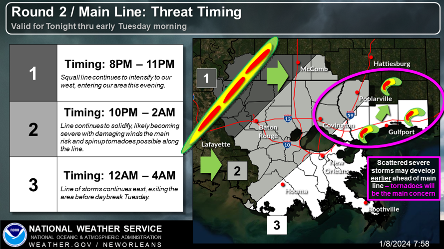
With the first storm system still threatening the New Orleans area late Monday, another one is expected overnight with a higher risk of tornadoes and damaging winds.
A cold front is bringing the second big line of strong storms across Louisiana, and it's expected to reach New Orleans between midnight and 4 a.m.
There is a higher risk of severe weather overnight, along with more rain and risk of flash flooding,
"It's the best chance to see the worst of it," National Weather Service meteorologist Megan Williams said.
But the first storm system won't clear the area until the next front arrives, and strong gusts and heavy rain remain a threat.
A tornado watch has been extended until 7 a.m. Tuesday, and there is a flood watch until 9 a.m., a high-wind warning until 3 a.m. and wind advisory through 6 p.m. Tuesday.
More advisories are likely with the second round of storms.

The powerful cold front has already dropped temperatures and brought winter weather across the country, with severe weather threats across the Southeast and into Florida.
Temperatures won't plummet immediately but are expected to be in the mid-30s in the New Orleans area by Wednesday morning.
Severe weather impact
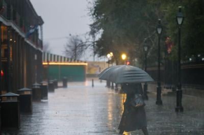
So far, the New Orleans airport has recorded a half inch to 3/4 inch of rain, Williams said.
About 1,700 Entergy customers were without power as of 7 p.m. after several neighborhoods in Jefferson Parish had outages. Across the state, more than 17,000 people were without power.
The strongest thunderstorms from the first round were to the west of the metro area, causing damage west of Thibodaux in Labadieville, along with hail and street flooding in Mandeville, the northshore and northern parts of the Mississippi coast.
"Please, please do not travel tonight, unless absolutely necessary," the St. Tammany Parish Government warned. "Another strong band of weather is predicted later tonight, now is not the time to put your guard down.”
The Causeway bridge also closed briefly because of high winds.
Before you go to bed tonight, make sure you have your WEA (Wireless Emergency Alerts) turned on! With the threat of severe weather overnight, including a threat for tornadoes, make sure you have a way to get warnings while you are asleep! #lawx #mswx pic.twitter.com/WmTILHesCI
— NWS New Orleans (@NWSNewOrleans) January 9, 2024
Forecast for NOLA
Tuesday: Mostly cloudy through mid-morning, then gradual clearing, with a high near 54 degrees. Breezy, with a west wind 20-25 mph and gusts as high as 35 mph.
Tuesday night: Clear, with a low around 38 degrees. Breezy, with a west wind of 15-20 mph decreasing to 10-15 mph after midnight. Winds could gust as high as 30 mph.
Wednesday: Mostly sunny, with a high near 55 degrees and a south wind of around 5 mph.
Wednesday night: Partly cloudy, with a low around 44 degrees and a south wind of around 5 mph until midnight.
Thursday: Mostly sunny, with a high near 65 degrees. There will be a southeast wind of 5-10 mph increasing to 10-15 mph in the afternoon.
Thursday night: A chance of showers, then showers and possibly a thunderstorm after midnight. Low around 58 degrees. Breezy, with a southeast wind 15-20 mph. Chance of precipitation is 80%.
Friday: Showers likely and possibly a thunderstorm before noon. Partly sunny, with a high near 70 degrees. Windy, with a south wind 20-30 mph becoming west in the afternoon. Winds could gust as high as 45 mph. Chance of precipitation is 60%.