


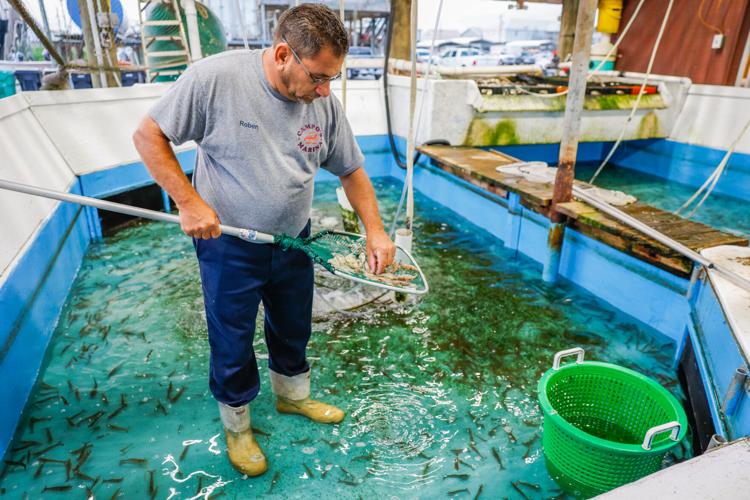
The sun is barely up and Robbie Campo is ankle-deep in a pool of water, sloshing around in shrimp boots and explaining why.

“I grew up poor,” the 55-year-old says as he works a skimmer net through the concrete pool, separating dead shrimp from live ones while anglers file through to buy bait. “You want it, you got to work for it. Ain’t no handouts.”
He has been here since 4 a.m., but that’s nothing new. He’s done the same thing since he was a kid, keeping an eye on the boat launch, watching the tides, advising weekend warriors on spots they might try to catch a few specks or reds.
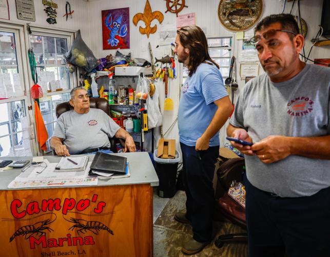
Some of the old-timers may notice a resemblance and connect the history. Campo, punctuating his points with salty language and a seen-it-all look, is part of the fourth generation to run the marina in St. Bernard Parish that the family says has existed in one form or another since 1903.
His 81-year-old father, Frank Campo Jr., is sitting at the desk in the office, the way he usually does, collecting payments for boat launches and bait, writing down sales by hand in a notebook. A black-and-white picture hangs on the wall nearby, taking another step back in time.
The picture is of Robbie’s late grandfather — Frank “Blackie” Campo, well-known among anglers in southeast Louisiana, his nickname attesting to his time spent in the sun — and his great-grandfather, Celestino Campo, both smiling as they pose next to a stringer of fish.

Frank Campo Jr., his grandson Nicholas Campo, and his son Robbie Campo work together at Campo's Marina in Shell Beach on May 13. Nicholas, who is studying to be an engineer, worries about who will take over the family business, saying he "doesn't want to see it go away."
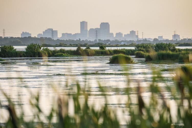
That continuity holds deep meaning in a tradition-bound state like Louisiana, so much so that it can disguise the transformation long at work. The Campos and their marina at Shell Beach have been at a crossroads of Louisiana coastal change, and more is on the way.
The site where the marina began is being relentlessly wiped off the map, eroded and severed from the mainland. The road that once led to it near the shores of Lake Borgne now reaches its end well before that spot.
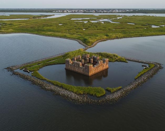
The remains of nearby Fort Proctor, built on land in the mid-19th century, now sit in the lake, a rock berm blunting the impact of the tides against its crumbling brick ramparts. From high above, it resembles a cardboard box set adrift.
And not far from where Robbie Campo is sifting through shrimp, a welded cross commemorating the victims of Hurricane Katrina rises where an infamous shipping channel was cut through in the 1960s all the way to New Orleans.

A barrier surrounds Fort Proctor, which was originally build on land in Shell Beach, La., Tuesday, July 18, 2023. (Photo by Sophia Germer, NOLA.com, The Times-Picayune)
All are evidence of the extreme challenge Louisiana faces. The state’s coast is disappearing, inch by inch, and the waters are rising. There are big plans to save as much of it as possible — but there will have to be sacrifices to salvage a sustainable future.
Robbie believes Campo’s Marina could be among them. One of the innovative solutions being pursued by the state will mean its death, he says.
The state’s coastal officials say that is not necessarily the case. They note, however, that change is inevitable — with or without that project — due to the forces putting Louisiana in such a perilous position.
“We’re just going to ride the wave all the way to the beach,” Campo said one recent morning as he sat behind the marina’s desk.
The canal where he has watched countless boats come and go, heading out with high hopes or returning with ice chests that tell the tale of how the fishing went, flowed past the window next to him.
“I mean, that's all I know how to do,” he said. “And when it hits the beach, well, then I might be too old to go do something different. I don't know. But as long as I can make a living on the water, I guess I'll be here making a living on the water.”
Louisiana 2050: Rising sea levels will upend life and bring new risk to the state over the next few decades.
Environmental reporter Mike Smith talked to people on the frontlines of Louisiana coastal change. Robert "Robbie" Campo, of Campo's Marina in Louisiana, has seen a lot of change since he was a kid growing up in Shell Beach.
Coastal Baton Rouge?
The water that surrounds south Louisiana is responsible for a unique way of life — one that it may ultimately drown. Because of climate change, the future is closer than many think.
Louisiana, by some estimates, is the state most at risk. It is also not prepared.
By 2050, just one generation into the future, the state will be dealing with intensifying dangers and some communities may be on the verge of disappearing.
Louisiana will be warmer and smaller, sea level rise will be gaining pace, storms will have intensified and firm decisions on how to manage the future should have already been taken.

Louisiana may be the state most at risk from climate change, and the year 2050 could prove to be an inflection point as seas rise and more lan…
Those decisions range from managing an energy transition away from fossil fuels to deciding whether to relocate especially vulnerable communities unlikely to survive — a controversial step for a list of reasons, particularly when it comes to Native American tribes.
Further complicating the dilemma, a steep drop-off in available coastal restoration and protection money will occur less than a decade from today, leaving Louisiana with a huge funding gap if a new source of money isn’t found. Insurance costs are also skyrocketing — sparking concerns that some locations may eventually become uninsurable.
Longer term, the prospects become increasingly dimmer.
Will Louisiana eventually see a retreat of its coastline all the way to Baton Rouge, roughly following today’s Interstate 12 and Interstate 10 corridor? It is not out of the question — and indeed a plausible scenario a couple centuries or so into the future, according to one Tulane geologist whose work on Louisiana’s coastal challenges has been closely followed.

While that is beyond anyone’s current lifetime, the same scientist, Torbjörn Törnqvist, says that later this century, areas such as Cameron Parish as well as lower Plaquemines, Terrebonne and Lafourche will already be vanishing.
Is the state relying too heavily on building levees and other flood protection measures? Craig Colten, an LSU geographer who has written extensively on Louisiana’s coastal challenges, believes that it is. The state must look harder at figuring out how to assist communities in relocating in a way that preserves their unique culture, he says.
He and others note that while many communities prefer to remain in place with bigger levees, those structures eventually become obsolete, if they are built at all, because of the rapidly changing landscape.
“I don't see a truly sustainable coast until the coast retreats further inland than it is now,” said Colten.
The state’s coastal officials say it will take a multi-faceted approach, but point out that flood protections have saved lives and livelihoods, and will continue to do so. For Bren Haase, the state’s coastal protection and restoration chief, Louisiana is more prepared than it has ever been thanks to recent progress — but he, too, readily acknowledges the immense challenges of the not-so-distant future.
Louisiana is so at risk because new dangers are being piled atop those that have long existed.
Sea-level rise exacerbated by climate change will combine with erosion and subsidence to further inundate coastal areas. Hurricanes and rainfall are expected to intensify.
Heat will worsen. Projections show temperatures in New Orleans by the 2050s steadily climbing — with average daily highs in the range of 82 degrees compared to 78.1 from the 1960s to the 1990s.

The New Orleans skyline, seen here from Chalmette, is perilously close to the eroding wetlands that once protected the city.
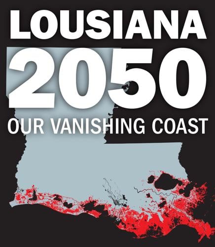
Consider these findings, based on data the state’s scientists use to compile their widely lauded master plan for the coast, which show 2050 as an inflection point for Louisiana:
- Louisiana could lose up to another 800 square miles of land by then. To put that in perspective, New Orleans is 170 square miles.
- In the most severe scenario modeled by the state, that amounts to about 27 square miles washed away each year, a rate 25% higher than from 1932 to 2015, when the state lost more than 1,800 square miles of wetlands.
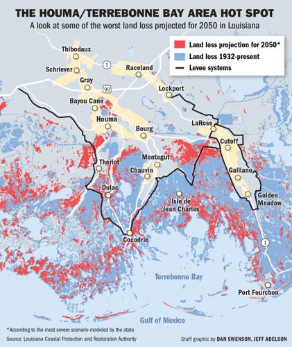
- Terrebonne Parish alone could lose up to 292 square miles in that time, nearly a third of its current land area. About 124 square miles in neighboring Lafourche could be gone.
- Another 136 square miles might be lost from Plaquemines Parish, all but eliminating the Bird’s Foot Delta, where the Mississippi River empties into the Gulf.
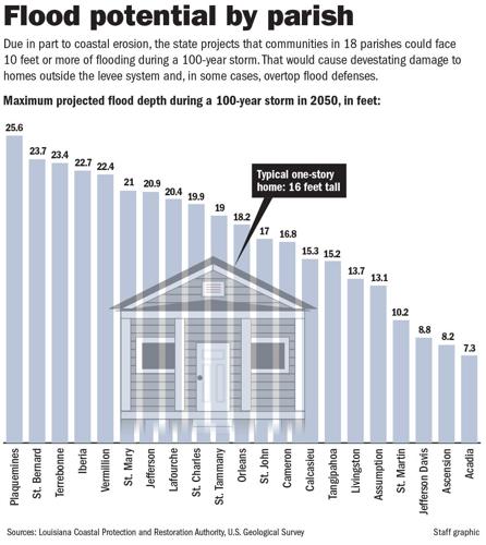
- Due to factors including land loss and intensified storms, the coastline will be more vulnerable to hurricanes. Models of particularly severe scenarios project that during floods with a 1% chance of occurring annually, depths of higher than 25 feet could hit communities in Plaquemines Parish by 2050, with other areas not far behind.
- That comes with costly devastation. Projections suggest that by 2050, flooding could cause annual damage of between $4 billion and $12 billion statewide on average, depending on factors like sea level rise and to what degree projects in the master plan are implemented. Those numbers could be far higher or far lower in any given year.
- Terrebonne could sustain about $2.6 billion in average annual damage under the most severe scenario that the state modeled, while St. Tammany Parish $2.3 billion.
- Along with Lafourche and St. Charles Parish, each of which could see more than $1.5 billion in damage, those areas would account for more than half the destruction statewide.
An important point related to those figures: They do not include wind damage.
As sobering as those projections are, the future does not have to be unrelentingly grim. Much will depend on how the state, nation and world respond to climate change, scientists who study the coast say. There are also unique opportunities.
Lowering emissions around the globe and limiting the increase in temperatures could head off the worst predictions of sea level rise. Louisiana, among the nation’s highest greenhouse gas emitters due to its petrochemical industries, will have to contribute to that effort.

Expertise gained in building coastal restoration and flood-protection projects could provide opportunities for Louisiana companies in other parts of the country and the world. The state’s offshore know-how could be put to use to produce wind energy. Carbon capture and sequestration, meanwhile, is also seen by state leaders as both an environmentally and economically beneficial solution that could be widely used here, though it remains unproven and controversial.
So much will depend on how Louisiana’s leaders respond. Gov. John Bel Edwards accepts the science around human-caused climate change and has sought to push Louisiana toward a net-zero carbon future. His administration has created the Gulf South’s first climate action plan but executing it will be up to future leaders.
Edwards, a Democrat, leaves office early next year, and the leading candidate to replace him, Attorney General Jeff Landry, has called human-caused climate change a “hoax.” When asked in June, the Republican and Donald Trump acolyte spoke of the need to address land loss and flood risks but declined to say whether his view had changed.
There is at least one sure bet: By 2050, Louisiana will have to be well on its way to learning how to live with a shrinking coast, rising seas and intensifying storms.
“Nobody really has a crystal ball, so answering that with any sort of level of certainty — you just can't do it,” Haase, the state’s coastal protection chief, said when asked what a sustainable coast might look like.
“But based on what we know, sustainable coastal Louisiana has a more compact footprint. As you're looking at some areas of the state, it'd be difficult to maintain this existing landscape there.”
Haase added, though, that he believes enough can be preserved to provide “much of the same sort of value and resources that it does today.”
‘Everything’s going to change’

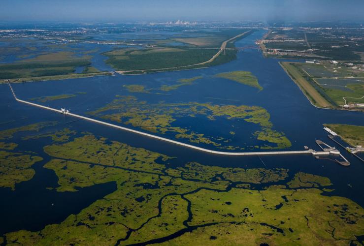
The Lake Borgne Surge Barrier photographed near New Orleans, La., Saturday, June 3, 2023. (Flight courtesy of SouthWings)(Photo by Sophia Germer, NOLA.com, The Times-Picayune)
The concrete rises above the marsh and brackish water at New Orleans’ doorstep like the walls of a castle, the city’s skyline in the distance beyond it. If it looks medieval, it is very much a modern marvel, both reassuring and intimidating, a hulking line of protection and a reminder of Louisiana’s extreme vulnerability.
Stretching nearly two miles and standing 25 feet above sea level, what is officially known as the IHNC-Lake Borgne Surge Barrier is designed to repel the wall of water that pushes toward New Orleans when hurricanes approach from the Gulf.
The “Great Wall of Louisiana,” as some have called it, wasn’t there when Jessica Dandridge’s parents’ houses flooded. In fact, the 2005 flood caused by the levee failures during Hurricane Katrina is the reason the wall exists.
Dandridge was only a teenager then — Katrina hit the day before her 16th birthday — but she remembers it. Her mother’s house in New Orleans East took on 13 feet of water; her father’s home in Gentilly 17 feet. She had evacuated to Lafayette.
As happened with so many New Orleanians, Dandridge’s life changed forever. Her family’s connections to the city are strong — they’ve run a Jamaican food booth at Jazz Fest for more than three decades, a legacy of her grandfather, an immigrant from the island. Her family found its way back home and rebuilt after a monthslong post-Katrina sojourn.
Now 34, she has pursued a career aimed at preventing such catastrophe — a career Katrina propelled her toward. She directs the Water Collaborative of Greater New Orleans, devoted to finding equitable ways of helping Louisianans live with the water that constantly threatens them. When contemplating the state’s future, she says uncomfortable conversations will be necessary.
Among them: whether to move entire communities; how to address the funding shortages plaguing New Orleans’ stormwater management; and how to strengthen building codes.
“We're the canary in the coal mine,” Dandridge says. “And so that means that we're more at risk. But we also have more opportunities.”

Jessica Dandridge, head of the Water Collaborative, poses on the levee by the Levee Exhibit Hall and Garden in New Orleans, Tuesday, April 11, 2023. (Photo by Sophia Germer, NOLA.com, The Times-Picayune)
Dandridge spoke at the site of the breach that destroyed much of Gentilly in 2005, not far from where she lived as a girl. A new levee and floodwall now run along that same spot at the London Avenue Canal. New houses dot surrounding streets, many of them raised off the ground, unlike in the past.
The structures along the canal are part of the same project that built the “Great Wall” 15 miles away, all key elements of the New Orleans area’s $14.6 billion levee and risk reduction system put in place after Katrina. The wall is among the most impressive and important parts of it, with storm surge no longer slowed by the swamps, marsh and barrier islands that have been logged, peeled away, drilled, cut through or paved over.
The Army Corps of Engineers built the new system and, along with the state, has set out plans for what its New Orleans district commander, Col. Cullen Jones, has called “Fortress Louisiana,” a series of levees, floodwalls, pumping stations and other protection measures extending across vast swaths of the state.
Whether a true fortress can be built, and in what timeframe, are however legitimate questions. Another issue will be whether the projects that are carried out will provide sufficient protection as storms grow stronger.
The New Orleans protection system is designed to keep out surge from a so-called 100-year storm, or one that has a 1% chance of occurring in any year. There are already discussions about whether it should be raised to the 200-year level given the intensification of hurricanes.
One study found that 100-year floods will occur far more frequently in the latter part of this century, as regularly as between every 5 and 30 years along the Gulf Coast.
Dandridge, who now lives in Metairie, says the state must prepare for that reality, while noting that Louisiana and New Orleans have already taken more action than some of their neighbors. She believes the state must learn to build smarter, in harmony with its flood-prone nature, rather than rely too heavily on the “dialysis” of man-made protection.
“I don't think we have a choice. And I think that's the uncomfortable conversation that no one wants to have,” Dandridge said of making firm decisions about where people can live, among other responses.
“Climate change means everything's going to change. I have a stepson who's 10, and his whole world's going to look absolutely different. And he's going to have to learn how to give up things that he doesn't want to give up. And it's not fair. But climate change isn't fair. The cause isn't fair.”
‘A problem that needs a solution’
The reasons why Louisiana cannot rely solely on huge projects such as the New Orleans area levee system come down to simple math. That system remains the largest such project ever built by the Corps, though it could eventually be surpassed by flood protection systems for the Houston and New York areas.
Resources are extremely limited, and competition nationwide is fierce.

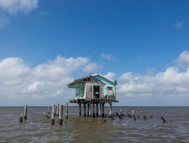
Wind, water and erosion have taken a toll on a fishing camp standing on piers in the water near Barataria Bay.
The Corps has a backlog of more than $100 billion worth of construction projects across the country, almost a tenth of it in Louisiana. The annual amount appropriated to the agency over the last three years averaged only a sliver of that — around $8 billion, according to Corps figures, though it’s unclear if that includes additional money allocated from legislation such as the 2021 infrastructure law.
The results of delays have been frustrating, and at times catastrophic.
Take what is known as the West Shore Lake Pontchartrain levee project to protect the River Parishes west of New Orleans from storm surge.
Though it was discussed for decades, ground wasn’t broken on the 17.5-mile levee system until 2021 — after catastrophic floods during 2012’s Hurricane Isaac and 2021’s Hurricane Ida. Both storms inundated thousands of homes.
Meanwhile, the Corps announced in July that the price tag had skyrocketed from $760 million to $3.7 billion — and more money must be found. It is currently scheduled to be completed in late 2026, though it is unclear if the new cost estimate will lead to further delays.
The 98-mile Morganza to the Gulf levee project, aimed at protecting parts of Terrebonne and Lafourche parishes, is another. Similarly discussed for decades, state and local authorities eventually began construction on their own, aided by local tax revenue, and have managed to build significant portions of it.
The good news is that, according to the Corps, around $680 million is currently in hand, a combination of federal money and work already done by local jurisdictions.
The bad news is that the money remains far short of the $5 billion price tag. That does not include another $5 billion needed to operate and maintain the levees at their proper heights over a 50-year period.
The federal government is not solely to blame. Local authorities have long allowed developers to build slab-on-grade houses in flood-prone areas. Residents facing the challenge of finding affordable homes often didn’t even seriously consider the risk.
The answer in some parts of the state may not be giant levee systems but targeted “nonstructural” approaches.
As one example, the Corps has embarked upon a home-raising program in especially flood-prone parts of southwest Louisiana. Enough funding has been made available so far — nearly $300 million — to elevate up to 1,000 houses.
Home elevations are also included in an overarching flood-reduction plan for St. Tammany Parish, which is not protected by levees. Federal money recently awarded to Louisiana is intended to allow for the elevation of around 750 structures statewide.
The Corps uses a cost-benefit analysis to determine which approach to pursue with flood-protection measures — a formula that is undergoing a rethink.
Separately, the state has or is in the process of carrying out 10 programs for voluntary buyouts or relocations, ranging in size from community-wide to parts of neighborhoods.
Massive amounts of money would be needed to scale up those programs.
Pat Forbes, head of the state’s Office of Community Development, which is overseeing the buyouts, says significant challenges include how to bring down costs and figuring out new locations for residents. But he believes that “it's going to be a problem that needs a solution.”
“And we're doing some things that hopefully are going to contribute to the global knowledge of how best to go about doing that,” said Forbes. “But nobody has a foolproof model right now.”
‘Everything’s sinking, right?’
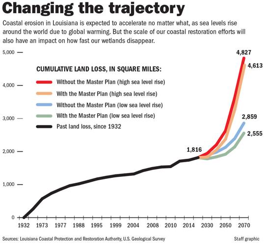
More broadly, the state’s coastal master plan, guided by scientific research, calls for spending $50 billion over 50 years. That amount includes $11.2 billion on “nonstructural” programs, such as flood-proofing, elevations and voluntary buyouts.

If the entire plan were to be carried out in full, the state’s Coastal Protection and Restoration Authority says Louisiana’s flood risk from storm surge could actually be less by 2070 than it is today, though that would be under a scenario where sea level rise and other factors are not as severe.
Big projects in the latest version of the master plan — updated every six years — include barriers to limit storm surge at the Rigolets and Chef Pass around New Orleans, a Lafitte ring levee, and further work on the Morganza to the Gulf system, among many others.
But it is reasonable to ask how much of that plan will be built in any current resident’s lifetime because of funding shortages — both existing and those on the horizon. While recent successes in coastal restoration and levee projects cannot be denied, that progress is ironically due in large part to another tragedy: the BP oil spill of 2010.
Louisiana’s share of money related to that spill for restoration has been put at $8.5 billion, and the state has used it to build massive coastal projects.
They include the restoration of more than 1,000 acres of barrier islands in the Terrebonne Basin; six miles of ridge and nearly 1,700 acres of marsh west of Venice; and an ongoing effort to rebuild 2,800 acres of marsh on the heavily eroded edge of Lake Borgne — within sight of Campo’s Marina.
The most expensive — and most controversial — project began construction on Aug. 10: the Mid-Barataria Sediment Diversion, at a cost of nearly $3 billion. Unprecedented in scope, it aims to turn back time in a sense, reconnecting the Mississippi River to the Barataria Basin, where some of the state’s biggest land loss has occurred.
But the BP money paying for those ambitious projects will not last forever — not even close. It will run out by 2032, and the state currently does not have a replacement lined up for it, though it is pursuing options.
They include proposed federal legislation that would increase the share of revenue states receive from offshore oil and gas production; extending that revenue sharing to future wind energy development, slated to begin soon in the Gulf; and exploring opportunities to earn revenue from carbon credits, thanks to the amount of CO2 that can be naturally absorbed by coastal restoration projects.
Additionally, parishes are pursuing damage lawsuits against oil companies, but their outcome is highly uncertain.
There have also been warnings that the actual cost of the state’s master plan will be tens of billions more than estimated due to inflation — and that the money simply will not be there. Local costs for flood control and drainage are rising, too, an issue that will have to be confronted as storms worsen.
Those pitfalls were pointed out in a 2015 paper by the Tulane Institute on Water Resources Law & Policy. Mark Davis, one of the authors, says those concerns have not abated.
Like many others, Davis lauds the state’s coastal master plan for delving into the climate-driven risks — an unwelcome discussion in many Southern states — and “creating a table to come and have that conversation.” But, he notes, the challenge is simply too large to leave it only to the state’s coastal protection authority.
“Plans that don't include plans to pay for it are not really plans at all,” he said. “They're discussion points — and very useful ones.”
Further, Davis says, even the projects that are built may be outdated by the time they’re completed.
“It’s sort of like, if I finally received by Amazon this afternoon the high school prom tuxedo I ordered,” he said. “It's not the tuxedo I need today. It won't fit me.”
Haase, who previously served as the coastal authority’s executive director and is now its chairman, agrees the actual costs of the projects listed will be higher due to inflation. The plan uses those numbers to be able to compare projects since the actual cost will depend on when construction begins, he said.
As for how many will actually be built, he contends they all stand a good chance, considering the options the state is pursuing to replace lost BP revenue.
“We can't give up. Not doing anything is just not an option,” Haase said. “And so even though we don't have every penny identified, or most identified, for all the projects at this point in time, we’ve got to keep pushing forward. We’ve got to keep our shoulder against that wheel.”
For Dandridge, it is time to look at the problem more broadly instead of gaining a “false sense of safety” from levees and similar projects. She points to the walls atop the London Avenue canal levees behind her and describes how those structures must be “maintained every day.”
“This is sinking — because everything's sinking, right?” she says. “And sea level rise risks are going up.”
Of the problem globally, she says: “Unfortunately, the poorest people and most vulnerable communities are going to feel it the most.”
“Drought, flooding, all that's going to lead to people moving, shifting.”
In some ways, it’s already happening. New Orleans’ population never fully recovered after Katrina. It remains down by more than 100,000 people. St. Bernard Parish is still down by over 20,000.
‘You can’t beat that’
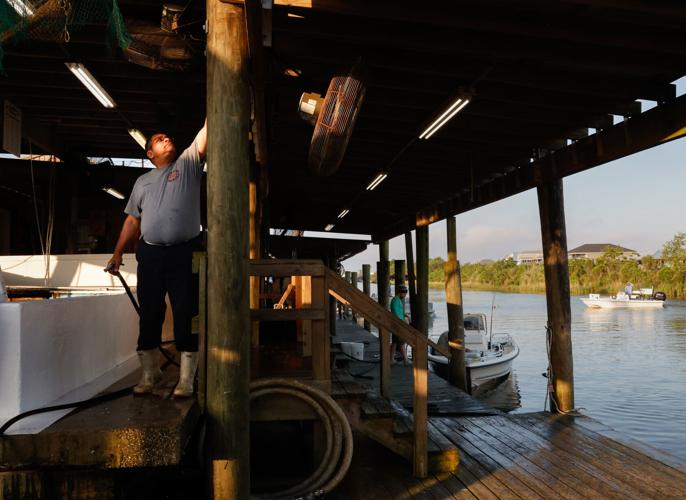
It is a busy Saturday in May at the marina, and the live shrimp are all sold before 7 a.m. Anglers looking for bait stare with long faces when they hear the news. Robbie Campo informs them that one of his sons and his brother are out on the boat catching more, and they can stop next to them on the water if they want to try to buy some.
Another of his sons, Nicholas, a 23-year-old engineering student, has been helping his dad sell bait. Robbie doesn’t expect he’ll be working at the marina after he earns his degree, though Nicholas says he worries about who’ll eventually take it over.

Robbie Campo, a member of the fourth generation of the family operating Campo's Marina, sorts live shrimp from dead ones on a Saturday in May.
“I don’t want to see this place go away,” Nicholas says. “It’s been a huge portion of my life. Just like my dad, the amount of people I’ve met here — people from all sorts of walks of life. I wake up every morning, I see the sun rise, I get to hang out with my grandpa, my dad and my uncle. You can’t beat that.”
Robbie says it’s hard to find young people to do the work. You’ve got to wake up early and get your hands dirty.
The marina has been through numerous transformations over the years. It has been rebuilt after repeated hurricanes. It survived the BP spill. It wasn’t always strictly a marina — nor was it always in its current location.
Its history is a cautionary tale for Louisiana’s coast.
Shell Beach started out about a mile away along the Lake Borgne waterfront, where a not-fully-realized earlier settlement known as Proctorville was located before the Civil War, said Bill Hyland, St. Bernard Parish’s historian. A rail line extended there, originally to transport sugar from the area’s slave-powered plantations.
It eventually attracted New Orleans families looking for a waterfront resort, and local settlers took advantage of business opportunities. They included Islenos families from the Canary Islands, dating to Spain’s control of Louisiana from 1762 until just before the Louisiana Purchase in 1803.
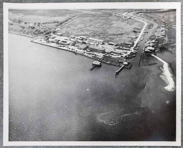
The Campo family was among them, and Celestino Campo — Robbie Campo’s great-grandfather — eventually started a grocery. He later had the idea to take families fishing with cane poles when they arrived on the train, Robbie says. A hand-drawn map shows the store’s location in 1938, part of archives from local historian Frank Fernandez, Anthony Fernandez Jr. and Benward Treadaway, now stored at Nunez Community College’s library.

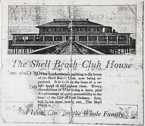
A copy of an old advertisement for the Shell Beach Club House, photographed at the Nunez Community College library in Chalmette.
An undated brochure depicts the nearby Shell Beach Club House, which sought to lure city families with descriptions of bountiful seafood and “a healthful, enjoyable, alluring summer resort.”
It boasted of being “just a good, fast run by automobile from the center of New Orleans.” Beyond hunting and fishing, the club house offered boating, bathing and dancing.
The seafood it touted illustrated a landscape with more extensive wetlands. The brochure spoke of “green trout” — bass, which thrive in fresher water — along with flounder, shrimp and oysters.
Later, a World War II-era naval anti-aircraft training center opened at Shell Beach.

A photograph in the Frank Fernandez Collection at Nunez Community College Library shows the Naval Anti-Aircraft Training Center in Shell Beach during World War II.
It would not be long before the land where all of that was situated would no longer be suitable for any kind of development.
Huge change came in the 1960s with the construction of the Mississippi River-Gulf Outlet, the shortcut from the Gulf to New Orleans carved through Shell Beach. That was when Campo’s — and all of Shell Beach — moved inland to where it is today.
Though the shipping channel never lived up to its billing and was closed after Hurricane Katrina, it did achieve an unfortunate outcome: It funneled in saltwater and put the erosion already taking place on hyperdrive.
Today, the land where the early incarnation of the marina, the resort and the base were located is just a patchwork of drowning marsh grass.
The state is spending $115 million in BP settlement money to restore it. Like other such marsh-building work, it will have a projected life span of around 20 years. They can and do last longer, but the bottom line is that rebuilt marshes erode like the rest of the coast.
‘These impacts are coming’
The Campos are glad to see that land being rebuilt, but they curse another upcoming project that they fear will do what hurricanes and a giant oil spill could not: put them out of business.
That project might be considered one of two crown jewels of the state’s ambitious coastal program. It is the Mid-Breton Sediment Diversion, which would funnel Mississippi River water and sediment from a spot west of Campo’s into the Breton Sound Basin.
It’s the east bank equivalent of the Mid-Barataria Sediment Diversion, though with about a third less capacity. The state recently broke ground on Mid-Barataria, which is expected to take around five years to complete. Mid-Breton is further away, with final permits possible from the Corps around April 2026.
The problem for the Campos is that the diversion will not only build land; it will also bring fresh water. Robbie Campo says the brackish-to-saltwater fishery he has known his entire life will change drastically.
Haase, the CPRA chairman, says the area surrounding Campo’s itself is far enough away from the diversion that it shouldn’t see seismic change. The diversion will also operate at varying capacities throughout the year.
Robbie Campo doesn’t buy it, while also noting that anglers launching from there travel to varying locations. He questions whether shrimping and targeting speckled trout — prized by just about everyone who puts in at Campo’s — will still be possible. He believes his family’s oyster leases are doomed.
Asked whether lessons could be learned from the marina’s long-ago history, in the days before the MRGO shipping channel, he says that is unrealistic. He lashes out in blunt language.
“We’re five generations into this thing,” he says, counting his children. “One of these days there’s going to be an end. There’s going to be an end to all commercial fishing down here.”
The state has not been blind to those concerns. The cost of the Mid-Barataria project on the west bank includes $378 million to assist those impacted by the diversion. Details are still being worked out for Mid-Breton, and an environmental impact study from the Corps is being conducted.
State officials add that heavy damage to fisheries will occur even if nothing is done. Haase points to ongoing declines in speckled trout and redfish due in part to the loss of habitat. He says healthy wetlands along the coast will ultimately lead to a productive ecosystem, even if certain species are not in the same locations.
“These impacts are coming to our coast if we don’t do anything to restore it,” said Haase.
‘Until the end
To understand why the state is pursuing such controversial projects, it is important to consider why sea level rise is such a threat here. An unfortunate brew of man-made circumstances is to blame.
South Louisiana was built by the Mississippi River as its path shifted over time, depositing sediment along the way. That process ended for good with the flood of 1927, which spurred the country to embark on a major levee project that has kept the river in place ever since.
While that keeps out flooding, it also prevents the coast from being enriched with new soil.
Other factors have played major roles. The oil and gas industry cut thousands of miles of canals through coastal wetlands for drilling and pipelines, helping speed erosion. The extraction of oil and gas also contributed to the land sinking because of the fluids being pulled out of it. Invasive species like nutria and roseau scale insects can also be destructive.
From 1985 to 2010, the equivalent of a football field vanished per hour on average, according to U.S. Geological Survey data. Since 1932, the state has lost about 2,000 square miles — around the size of Delaware.
Sea level rise is now posing a further threat, with Louisiana’s coast projected to see a net increase this century of more than 2 feet by 2050, data from NOAA shows. By 2100, that could rise to between 4 and 9 feet under various scenarios.
The state spends millions of dollars restoring and rebuilding wetlands each year, but readily acknowledges that those projects eventually erode again.
That’s why the diversions have been pursued. Those projects, if they succeed, reconnect the river to the disappearing wetlands, partly setting it loose to do its work.
They are supported by research, but they have also never been done at such a scale before. For commercial fishers and their supporters, the diversions are too much of a risk and too little benefit for the cost. The Mid-Barataria project is expected to build 21 square miles of land after 50 years — more than 10,000 football fields.
While many scientists back them, they have not gained unanimity. Colten, the LSU geographer, is among those who say they’re not worth it considering the damage that will occur to Louisiana’s fishing communities.

Robbie Campo cleans up the family-run marina in Shell Beach on a Saturday morning in May. Campo's sold out of shrimp before 7 a.m. that day.
Robbie Campo does not mince words.
On a quiet morning in February, he sat in the marina office, the summer rush still months away. Asked about the picture of his grandfather on the wall, he describes how he ran the place back when Robbie was a kid.
“He was the kingpin, brother. He was the boss,” he says. “What he said went. You did what he said.”
He lived with his grandparents most of his life at Shell Beach, he said.
“Look, I was born and raised on this bayou. I wasn’t leaving for no love or money in the world,” Robbie says.
The marina is a classic south Louisiana launching spot, equipped with little more than the essentials: a backdown boat ramp, small office, bait wells, dock, gas and ice. Customer tickets are taped to the office window.
But while Campo’s is familiar, so much else has changed. Robbie says you can’t catch fish the way he used to as a kid. Asked whether he thinks it’s because of the loss of habitat — land loss — he says “absolutely.” He reels off a list of the Chandeleur Islands east of here that are now vanishing.
“People lived on Freemason Island,” Robbie says, his voice rising.
Robbie doesn’t live in Shell Beach the way his grandparents did. He’s in Meraux, inside the levee protection system.
It’s only logical. He had homes in both locations when Katrina hit, and other members of the family also lived in Shell Beach at the time.
So much water and wind swept through that nothing remained of their houses.
“Blew them apart,” Robbie says.
Even if he were to risk it outside the levees, he says the cost of insurance would be too high.
They rebuilt the marina, as they had in the past. Now he hopes its days aren’t truly numbered, like so much else along Louisiana’s coast.
His dad recently decided to retire. Robbie, though, is a long way from calling it quits.
“That was the beginning,” he says of the early days, under his great-grandfather. “And I’ll be here until the end.”
Data editor Jeff Adelson contributed to this report.