

The first round of severe weather brought heavy rain and strong winds to south Louisiana on Monday, with the storms knocking out power to thousands of people in New Orleans and Baton Rouge metro areas.
The second wave is beginning to move through the state, with the worst of the weather for New Orleans projected to come between midnight and 4 a.m. Tuesday. Thunderstorms and flash flooding are likely, and tornadoes are possible.
New Orleans, Baton Rouge and the Mississippi Coast are all under a tornado watch until 7 a.m. Tuesday.
Earlier in the day Monday, the severe weather also took a toll on the Mississippi Coast. From Hancock County to Wiggins, several residents experienced hail, some the size of golf balls, falling from the sky.
Many shared the videos of the hail on social media. Here's what it looked like.
Big hail in Wiggins
Golf ball-sized hail fell in Wiggins on Monday afternoon. A viewer provided photos of it meteorologist Wesley Williams for WLOX-TV in Biloxi.
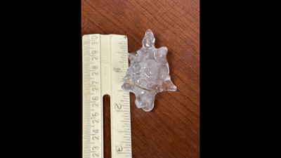
Dime sized hail in Poplarville
A viewer sent WLOX video of dime and pea sized hail falling in Poplarville around 3 p.m.
Hail in Saucier
Reports of hail falling in Saucier on Monday evening, which is in Harrison County, were confirmed by videos seen on social media.
Looks like an ice storm in the Kiln
A big hail storm Hancock County's Kiln on Monday night left the ground looking like it was the middle of a winter ice storm. A WLOX viewer sent in video from her home to meteorologist Eric Jeansonne.
That storm tracking through Hancock County is a big hail producer! This is in the Kiln. Video by Jackie Polk
— Eric Jeansonne (@Weatheric) January 9, 2024
via the @WLOX Weather App. #mswx @NWSNewOrleans pic.twitter.com/osTpDN3VbK
Louisiana sees some hail, too
The Felicianas saw hail storms earlier Monday, as did the National Weather Service office in Lake Charles.
The NWS describes hail as golf ball sized when it is about 1 3/4 inches in diameter.