


Louisiana and the Mississippi Gulf Coast are bracing for extreme weather forecast for the region later Monday and into Tuesday. The latest updates are below.
For a list of New Orleans area school closures, click here. See Baton Rouge school closures here. A timeline of when to expect bad weather can be found here. Also check out a gallery of photos from the region.
Tornado warning, LaPlace, Frenier

A tornado warning was issued at 12:46 a.m. Tuesday for portions of central St. John the Baptist and northwestern St. Charles parishes until 1:15 a.m. A severe thunderstorm capable of producing a tornado was located over LaPlace, moving east at 35 mph. It's headed in the direction of Frenier.
This warning includes Interstate 10 between mile markers 205 and 214, and I-55 between mile markers 1 and 4.
[12:50am 1/9/24]⚠️🌪️ Tornado risk is beginning to materialize along the line of storms and across Coastal MS. Stay weather aware and seek shelter if a warning is issued for your area! https://t.co/DhlbAOXbWn pic.twitter.com/Zmqk3qSuME
— NWS New Orleans (@NWSNewOrleans) January 9, 2024
Squall line moving east

Forecasters issued two special weather statements at 12:34 a.m. and 12:36 a.m. Tuesday for two separate batches of thunderstorms contained in the squall line moving east through the New Orleans area overnight.
The first one was for a group of storms along a line extending from near Covington to 10 miles north of LaPlace, moving east at 25 mph. These storms have wind gusts of 40 to 50 mph and pea-size hail.
This batch could impact Slidell, Picayune, Covington, Pearl River, Abita Springs, Madisonville, Lacombe, Stennis Space Center and the Slidell Airport, as well as sections of Interstates 10, 12, 55 and 59.

The second cluster of storms were being tracked along a line from 7 miles north of Reserve to near Schriever, and also were accompanied by wind gusts of 40 to 50 mph and pea size hail.
These storms are expected to also cross over New Orleans, Thibodaux, Reserve, Avondale, Metairie, Hahnville, LaPlace, Jefferson, Harahan, Westwego, Gramercy, Lutcher, Lockport, Mathews, Schriever, Montz, Luling, Garyville, River Ridge, and Boutte.
These storms also could affect portions of Interstates 10, 55, 310 and 610.

As a squall line accompanying a cold front moves through southeast Louisiana just after midnight, a few locations continue to see severe thunderstorms accompanied by heavy rains, while locations on the west side of the line begin being dropped from a regional tornado watch.
A severe thunderstorm was issued for northwestern Washington Parish at 12:12 a.m. Tuesday, and will remain in effect until 1 a.m., accompanied by potential wind gusts of 60 mph and penny size hail.
This storm was near Mount Herman, or 8 miles north of Franklinton, moving northeast at 60 mph.
A flash flood warning also was issued at 12:11 a.m. Tuesday for parts of Tangipahoa and Washington parishes and parts of Pike and Walthall counties in southern Mississippi until 3:15 a.m.
At 12:11 a.m., Doppler radar indicated thunderstorms were producing heavy rain in the area, with between 1.5 and 2.5 inches already fallen and another inch or two possible.
The tornado watch issued for portions of southeastern Louisiana, southern Mississippi and the Alabama coast through 7 a.m. has been dropped for East and West Baton Rouge, East Feliciana, Iberville and St. Helena parishes.
Forecasters also issued a tornado warming at 12:29 a.m. Tuesday for northeastern Harrison and northwestern Jackson counties in southern Mississippi for a severe thunderstorm capable of producing a tornado that was over Biloxi and moving northeast at 80 mph.
Forecasters with the Slidell office of the National Weather Service also announced just after midnight that they would conduct a storm survey on Tuesday morning near Labadieville in Assumption Parish to determine the amount of damage caused by severe thunderstorms that moved through the area on Monday. The results of the survey would be made public by late Tuesday afternoon.
Jefferson Parish schools to open
Jefferson Parish schools will open with a normal schedule on Tuesday, Jan. 9, the district said just after 8 p.m.
"If something changes, we will notify families and staff using district email and the Student Progress Center messaging system to communicate the latest information directly to families and employees."
Tornado watch extended
A tornado watch has been issued through 7 a.m. Tuesday for all of southeast Louisiana, south Mississippi and Alabama, and the Florida panhandle.
St. Tammany urges caution
St. Tammany Parish government issued a statement Monday night asking residents to avoid driving due to street flooding.
“We have received several inches of rain tonight," the statement read. "Some roadways, including on U.S. 190 in Mandeville, are experiencing water on the roads. Hail was also reported across the parish. Some homes were struck by lightning and a few trees were downed.
Our essential crews are on standby, ready to aid when conditions allow for safe travel.
Please, please do not travel tonight, unless absolutely necessary. Another strong band of weather is predicted later tonight, now is not the time to put your guard down. Monitor local media and our social media channels for the latest info.”
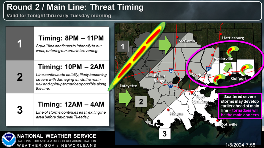
Second round of storms on the way
A second round of storms pushed into the metro area by a cold front is expected to arrive between midnight and 4 a.m.
There is a higher risk of tornadoes and damaging winds, along with more rain, National Weather Service meteorologist Megan Williams said.
"It's the best chance to see the worst of it," she said.

So far, the New Orleans airport has recorded a half inch to 3/4 of an inch of rain.
The cold front should drop overnight lows into the mid-30s by Wednesday morning.
Causeway reopens
The Lake Pontchartrain Causeway has now reopened in both directions, officials said at 5:53 p.m. It had closed earlier due to high winds and storms. There were also reports of hail in the Mandeville area Monday evening.
Flooding reported on I-12 and in LaPlace
Several inches of water flooded a section of Interstate 12 between Covington and Slidell, the NWS says. In LaPlace, flooding was reported along Windsor Boulevard in the River Forest subdivision. Water was covering streets and some garages were flooded.
House collapses in Treme
Strong winds likely blew down a building in the Treme neighborhood, New Orleans Fire Department Capt. Ed Holmes said.
No one was living in the building in the 1800 block of St. Philip St., he said. It was listed as unoccupied/abandoned and not connected to utilities.
No injuries were reported.
See live radar
You can watch the bad weather roll in by checking out this live radar view.
Heavy rain, flash flooding update
The chance of widespread flash flooding across southeastern Louisiana and southern Mississippi is expected to increase through Monday night, according to the National Weather Service. It said flash flooding is likely in "numerous areas," including New Orleans. Rain is expected to reach 3 to 6 inches, with 8+ inches possible in southern Mississippi.
The heavy rainfall results from a complex combination of a warm front that's draped across southern Louisiana into the Gulf, which is dragging up moisture and causing instability in the atmosphere likely to support strong thunderstorms. It will be followed by a strong cold front overnight, that could produce even stronger thunderstorms, forecasters say.
The front will be marked by a strong squall line of thunderstorms that may include bowing sections that could produce very strong tornadoes, forecasters said.
The heavy rainfall also is expected to swell streams and rivers overnight and early Monday, which could result in "rapid-onset flooding, from Baton Rouge, La., to Mobile Bay."
The highest probability of the high water overtopping river banks is along the lower Pearl River Basin in Louisiana and Mississippi, the message said.
Flash flood warning

A flash flood warning has been issued for parts of Assumption, Lafourche, St. Charles, St. James and St. John the Baptist parishes until 8 p.m. Monday, according to NWS.
At 4:54 p.m., Doppler radar indicated thunderstorms producing heavy rain across the warned area. Between 1.5 and 3.5 inches of rain have already fallen and another 1 to 2 inches are possible. Flash flooding is ongoing or expected to begin shortly, forecasters said.
Locations expected to see flash flooding include Napoleonville, Reserve, Laplace, Hahnville, Gramercy, Lutcher, North Vacherie, South Vacherie, Convent, Chackbay, Wallace, Garyville, Edgard, Labadieville, Killona, Supreme, Montz, Taft, Paincourtville and Norco.
Portions of I-10 between mile markers 201 and 212, and between mile markers 215 and 219 are also in danger of flooding, as part parts of I-55 between mile markers 1 and 4.
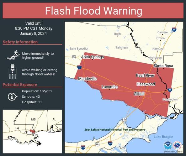
St. Tammany flood advisory and flash flood warning

A flood advisory is in effect for part of southwestern St. Tammany Parish until 7 p.m. Monday for possible minor flooding in low-lying and poor drainage areas, including the possibility of water over roadways.
At 5:05 p.m., residents reported heavy rain causing urban and small stream flooding, with between 1.5 and 2.5 inches having fallen. Another 1 to 2 inches of rain is expected during the next few hours.
Locations expected to see flooding include Covington, Abita Springs, Madisonville and Lacombe.

A flash flood warning is in effect for parts of St. Tammany Parish, including the advisory area as well as Slidell, Covington, Pearl River, Abita Springs and Lacombe, along with Stennis Space Center and Pearlington in Mississippi.
At 5:18 p.m., Doppler radar indicated thunderstorms had produced between 2.5 and 3.5 inches of rain across the area and another 1 to 3 inches were possible. Flash flooding is ongoing or expected to begin shortly.
This warning includes parts of I-1o betweeen mile markers 1 and 2 and 261 and 273, I-12 between markers 62 and 84, and I-59 between markers 1 and 10.
Tornado watch

A tornado watch has been issued for all of southeast Louisiana, including New Orleans and Baton Rouge, and extending east into southern Mississippi, through 9 p.m. Monday.
A tornado warning was issued earlier Monday for portions of St. John the Baptist, St. James and Lafourche parishes until 5 p.m., but expired at 4:23 p.m., when the storm posing the threat weakened below severe limits and exited the warning area.
Earlier on Monday, a tornado watch was issued for western portions of Louisiana and eastern Texas. That watch also remains in effect until 9 p.m.
Power outages
Some 5,880 Louisiana customers were without power statewide as of around 4:30 pm, the poweroutage.us website reports. That includes about 115 in Orleans parish, says the site, which tracks outages nationwide across various utility providers.
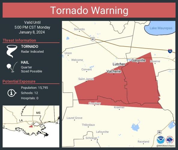
Tornado warning for St. John, St. James, Lafourche parishes

A tornado warning has been issued for portions of southwestern St. John the Baptist, southeastern St. James, and north central Lafourche parishes until 5 p.m. Monday.
At 3:58 p.m., a severe thunderstorm capable of producing a tornado was located near Chackbay, or 9 miles north of Thibodaux, moving east at 20 mph. Quarter-size hail is also possible with this storm.
Other locations in the path of this storm include South and North Vacherie, around 4:05 p.m.; Wallace, around 4:20 p.m; and Edgard, around 4:25 p.m.
Special weather statement, 3:50 p.m

A strong thunderstorm will impact portions of northwestern St. John the Baptist, Ascension, St. James, central Livingston, northern Lafourche, southern East Baton Rouge, and north central Assumption parishes through 4:30 p.m. Monday.
At 3:50 p.m., Doppler radar was tracking this strong thunderstorm near Convent, or 8 miles southeast of Donaldsonville, moving northeast at 50 mph. Expect winds in excess of 40 mph and half-inch hail with this storm.
Other locations that could be affected include Gonzales, Donaldsonville, Reserve, Laplace, Walker, Gramercy, Lutcher, Livingston, Sorrento, French Settlement, Port Vincent, Geismar, Convent, North Vacherie, Garyville, Prairieville, Wallace, Whitehall, Edgard, and Chackbay. It also could affect Interstate 10 between mile markers 171 and 207, and I-12 between mile markers 15 and 25.
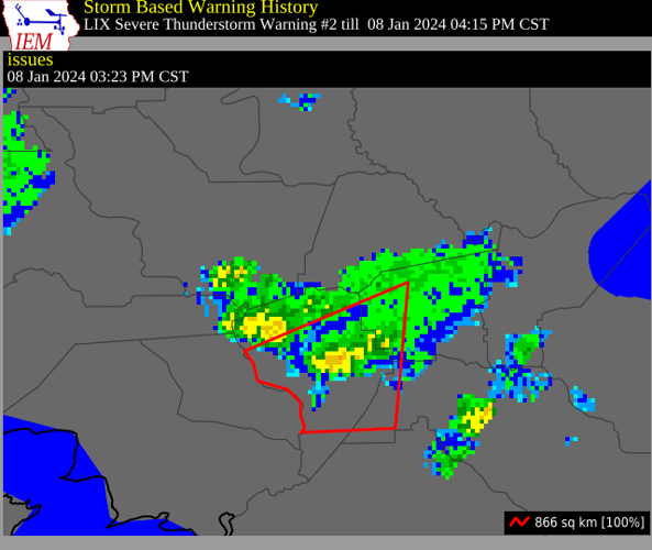
Severe thunderstorm warning, 3:23 p.m

A severe thunderstorm warning has been issued for parts of southwestern St. James, northwestern Lafourche and Assumption parishes until 4:15 p.m. Monday, according to the Slidell office of the National Weather Service.
At 3:23 p.m., this storm was located over Stephensville, moving northeast at 35 mph. 60 mph wind gusts and half-dollar size hail is possible with this storm.
Other locations that will be impacted include Napoleonville, Supreme, Labadieville, Paincourtville, and Belle Rose.
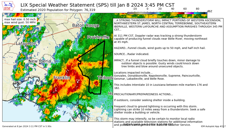
Special weather statement, 3:11 p.m.

A strong thunderstorm will impact parts of western Ascension, northwestern St. James, north central Terrebonne, Southeastern Iberville, western Lafourche and Assumption parishes through 3:45 p.m., according to a special weather statement issued by the Slidell office of the National Weather Service.
At 3:11 p.m., Doppler radar was tracking this storm, capable of producing funnel clouds, near Belle River, moving northeast at 45 mph. This storm also has the potential of wind gusts up to 50 mph and half-inch hail.
The warning area includes Gonzales, Donaldsonville, Napoleonville, Supreme, Paincourtville, Geismar, Labadieville, and Belle Rose, as well as portions of Interstate 10 between mile markers 176 and 182.
Special weather statement, 2:11 p.m.

A strong thunderstorm will impact portions of west central St. John the Baptist, southeastern Ascension and St. James parishes through 3:15 p.m., according to the National Weather Service. This is the third of three weather statements and warnings issued about separate storms in some of these areas.
At 2:41 p.m., Doppler radar was tracking a strong thunderstorm over Convent, or 12 miles east of Napoleonville, moving north at 50 mph. This storm is expected to have wind gusts of up to 50 mph and half-inch size hail.
Other locations that could be impacted include Gramercy, Lutcher, Sorrento, Convent, Garyville, North Vacherie and Wallace. This includes Interstate 10 between mile markers 182 and 200.
Severe thunderstorm warning, 2:37 p.m.

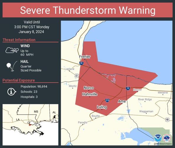
A severe thunderstorm warning has been issued for portions of St. John the Baptist, St. Charles and Jefferson parishes until 3 p.m., according to the Slidell office of the National Weather Service.
At 2:37 p.m., a severe thunderstorm was located over Destrehan, or near Hahnville, moving northeast at 45 mph.
This storm is expected to include 60 mph wind gusts and quarter size hail. Hail damage to vehicles is expected, and wind damage to roofs, siding and trees is possible.
Locations at risk from this storm include Hahnville, LaPlace, Metairie, Norco, Taft, New Sarpy, St. Rose, Ama, Luling and Montz. The warning includes portions of Interstate 10 between mile markers 210 and 224 and I-310 between mile markers 1 and 8.

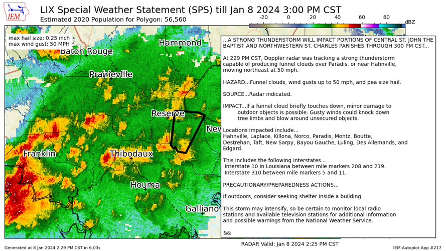
St. John, St. Charles alerts, 2:29 p.m.
A strong thunderstorm will impact portions of central St. John the Baptist and northwestern St. Charles parishes through 3 p.m. Monday, according to a special weather statement issued by the Slidell office of the National Weather Service.
At 2:29 p.m., Doppler radar was tracking a strong thunderstorm capable of producing funnel clouds over Paradis, or near Hahnville on the West Bank, moving northeast at 50 mph.
This storm has the potential of producing funnel clouds, wind gusts up to 50 mph and pea size hail.
The warning area includes LaPlace, Killona, Norco, Montz, Boutte, Destrehan, Taft, New Sarpy, Bayou Cauche, Luling, Des Allemands and Edgard, as well as portions of Interstate 10 between mile markers 208 and 219, and I-310 between mile markers 5 and 11.
The National Weather Service has also issued a special weather statement for a strong thunderstorm capable of producing funnel clouds that will impact portions of St. John the Baptist, St. James, St. Charles and Lafourche parishes through 2:45 p.m. Monday. At 2:03 p.m., Doppler radar was tracking a strong thunderstorm capable of producing funnel clouds near Raceland, or 7 miles north of Houma, moving northeast at 40 mph, it said. The warning includes portions of Interstate 310 between mile markers 8 and 11.
Heavy rain increasing
Forecasters with the National Weather Service are warning that heavy showers and thunderstorms will become more frequent in western and central Louisiana during the afternoon hours, our weather expert Mark Schleifstein reports. The trigger for the increased activity, which has already sparked hail of 2 ½ inches or greater in the Lake Charles area, is convection forming in response to warm air from a warm front. That has combined with wet air surging in from the Gulf of Mexico, all in advance of a very strong cold front that’s expected to deliver even more strong storms overnight.
In one thunderstorm near Hackberry in Cameron Parish, a recreational vehicle and outbuilding were flipped over and a power line was damaged, according to a report to the Lake Charles National Weather Service office.
The NWS also warned that a more significant threat of heavy rainfall and flash flooding may show up later Monday evening to areas farther east, including the Baton Rouge, New Orleans and southern Mississippi areas.
Tornado watch
A tornado watch has beenn issued for parts of southwestern Louisiana, in effect from 1:35 pm to 9 pm. It extends from west of Houston to about 15 miles east/southeast of Lafayette. See the advisory here.
NWS video updates
Check out the latest video update from the National Weather Service, which warns that the bad weather is "quite the complicated system" and there could be "multiple rounds."
An update on wind speeds can be found here. At 10:35 am, the highest gust so far was 38 mph at City Hall in New Orleans, but the NWS warns "this won't last long."
Causeway remains open
The Lake Pontchartrain Causeway remains open and management is hoping to keep it that way, though it will depend on wind speeds, which are being monitored. The decision is based mainly on the strength of crosswinds and whether they pose a danger to drivers, says bridge general manager Carlton Dufrechou.
"We'll be here around the clock and hopefully we won't have to close," says Dufrechou.
Hail reported
The NWS says it received a report of small hail in West Feliciana Parish, north of Baton Rouge. See tweet with photo here.
Neutral ground parking
Neutral ground parking in Orleans Parish is lifted from 10 a.m. Monday until 9 a.m. on Tuesday, Jan. 9, according to a city announcement. The New Orleans Office of Homeland Security and Emergency Preparedness has activated the Emergency Operations Center and will monitor conditions throughout the weather event, the announcement said.
Power outage maps
The strong winds and storms associated with the weather systems have potential to knock out power, the National Weather Service says. Go here to see power outage maps for Entergy and Cleco customers.
New Orleans closures
City Hall will close at noon on Monday ahead of the severe weather, according to an alert from NOLAReady. Municipal and traffic court closed at noon. The Housing Authority of New Orleans also closed at noon.
Sewerage & Water Board preparations
The Sewerage & Water Board has just enough power to run New Orleans' drainage pumps ahead of expected intense rainstorms and flash flooding across southeast Louisiana, according to the utility. Read the full story here.
Kenner closures
The city of Kenner said it would close its administrative offices at noon on Monday ahead of the severe weather. It also canceled indoor and outdoor recreation programming.
St. Tammany closures, sandbags available
St. Tammany Parish government offices and library branches closed at noon today. Also, sandbags are available starting at noon at the below locations. Sandbags are self-service and limited to 15 per person. Residents should bring their own shovels.
- Covington Public Works Barn @ 1305 N. Florida Street, Covington.
- St. Tammany Parish Government Complex @ 21410 Koop Drive, Mandeville.
- Fritchie Public Works Barn @ 63119 Hwy 190, Pearl River.
- Airport Road Public Works Barn @ 34583 Grantham College Road, Slidell.
- Keller Public Works Barn @ 63131 Fish Hatchery Road, Lacombe.
- Old Levee District Site @ 61134 Military Road (Hwy 190), Slidell.
UNO holding classes remotely
The University of New Orleans will hold classes remotely starting at 12 p.m. Non-essential personnel can also work remotely starting at noon. The library and Privateer Enrollment Center will remain open until 4:30 p.m. The men’s basketball home game has been moved up to 1 p.m., the university reports.
Court closures
Orleans Parish Civil District Court and First and Second City courts are closed, and Orleans Parish Criminal District Court closed as of 11 a.m. Monday.


